
Thank you for supporting this site ❤️
Make a donation
Make a donation
Gear up for your next adventure:
As an Amazon Associate, this site earns from qualifying purchases at no extra cost to you.
Palomino topographic map
Click on the map to display elevation.
Thank you for supporting this site ❤️
Make a donation
Make a donation
Gear up for your next adventure:
As an Amazon Associate, this site earns from qualifying purchases at no extra cost to you.
About this map
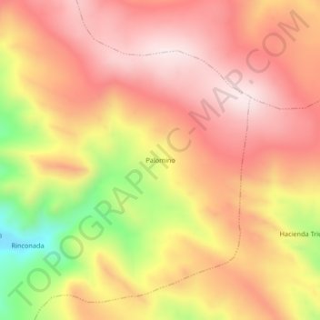
Name: Palomino topographic map, elevation, terrain.
Location: Palomino, Asillo, Azángaro, Puno, Perú (-14.69380 -70.28061 -14.65380 -70.24061)
Average elevation: 13,957 ft
Minimum elevation: 12,851 ft
Maximum elevation: 14,587 ft
Thank you for supporting this site ❤️
Make a donation
Make a donation
Gear up for your next adventure:
As an Amazon Associate, this site earns from qualifying purchases at no extra cost to you.