Geolocate

Putnam Hall topographic map

Click on the map to display elevation.

About this map

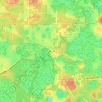
Name: Putnam Hall topographic map, elevation, terrain.

Location: Putnam Hall, Putnam County, Florida, 32185, United States (29.71663 -81.97926 29.75663 -81.93926)

Average elevation: 112 ft

Minimum elevation: 33 ft

Maximum elevation: 177 ft

Putnam County trails, hiking, mountain biking, running and outdoor activities

Other topographic maps

Click on a map to view its topography, its elevation and its terrain.

Interlachen

United States > Florida > Putnam County

Average elevation: 102 ft

Palatka

United States > Florida > Putnam County

Palatka is located at 29°38′N 81°39′W / 29.633°N 81.650°W / 29.633; -81.650. The total area is 7.5 square miles (19 km2) and has an average elevation of 16 feet (4.8 m) above sea level. The city is located in the southern portion of the Lower St. Johns River basin.

Average elevation: 26 ft

East Palatka

United States > Florida > Putnam County

Average elevation: 20 ft

Crescent City

United States > Florida > Putnam County

Average elevation: 36 ft

Mariner Lake

United States > Florida > Putnam County

Average elevation: 121 ft

Crescent City

United States > Florida > Putnam County

Average elevation: 36 ft

Dunns Creek

United States > Florida > Putnam County

Average elevation: 23 ft

Interlachen

United States > Florida > Putnam County

Average elevation: 102 ft

Palatka

United States > Florida > Putnam County

Palatka is located at 29°38′N 81°39′W / 29.633°N 81.650°W / 29.633; -81.650. The total area is 7.5 square miles (19 km2) and has an average elevation of 16 feet (4.8 m) above sea level. The city is located in the southern portion of the Lower St. Johns River basin.

Average elevation: 26 ft

East Palatka

United States > Florida > Putnam County

Average elevation: 16 ft

Palatka

United States > Florida > Putnam County

Average elevation: 26 ft

Dunns Creek

United States > Florida > Putnam County

Average elevation: 23 ft

Pomona Park

United States > Florida > Putnam County > Pomona Park

Average elevation: 59 ft

Gear up for your next adventure:

📱Solar Portable Charger - Solar power bank for charging devices off‑grid
🛰️Handheld GPS Units - Professional satellite navigators for precise backcountry mapping
🥾Hiking Shoes - Durable and comfortable shoes for trail hiking
🪄Magnetic Compass - Accurate compass for navigation
🏫Relief Map Kits - Hands-on tools for teaching landforms and elevation

As an Amazon Associate, this site earns from qualifying purchases at no extra cost to you.