Geolocate

Linden topographic map

Click on the map to display elevation.

About this map

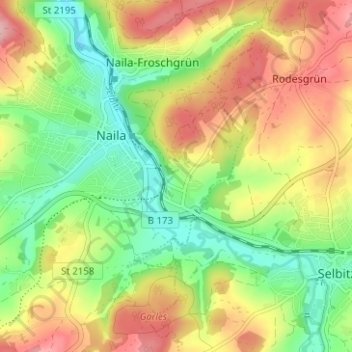
Name: Linden topographic map, elevation, terrain.

Location: Linden, Naila, Landkreis Hof, Bavaria, 95119, Germany (50.30500 11.69994 50.34500 11.73994)

Average elevation: 1,827 ft

Minimum elevation: 1,611 ft

Maximum elevation: 2,083 ft

Gear up for your next adventure:

🧭GPS Watch Accessories - Bands and chargers for GPS watches
🪶Thermal Camp Blanket - Extra warmth for cold nights
🏫Relief Map Kits - Hands-on tools for teaching landforms and elevation
🧣Merino Neck Gaiters - Multi-functional headwear for wind and sun protection
🌄Hiking Binoculars - Compact binoculars for scenic views and trail spotting

As an Amazon Associate, this site earns from qualifying purchases at no extra cost to you.