Geolocate

Sharpsburg topographic map

Click on the map to display elevation.

About this map

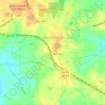
Name: Sharpsburg topographic map, elevation, terrain.

Location: Sharpsburg, Coweta County, Georgia, United States (33.32400 -84.66096 33.34675 -84.63958)

Average elevation: 896 ft

Minimum elevation: 827 ft

Maximum elevation: 958 ft

Coweta County trails, hiking, mountain biking, running and outdoor activities

Other topographic maps

Click on a map to view its topography, its elevation and its terrain.

East Newnan

United States > Georgia > Coweta County

Average elevation: 951 ft

Arnco Mills

United States > Georgia > Coweta County

Average elevation: 840 ft

Thomas Crossroads

United States > Georgia > Coweta County

Average elevation: 928 ft

McBride

United States > Georgia > Coweta County > Newnan

Average elevation: 919 ft

McCollum

United States > Georgia > Coweta County

Average elevation: 932 ft

Gear up for your next adventure:

🧥Waterproof Jacket for Hiking - Breathable and rugged rain jacket for outdoor excursions
👓Polarized Sunglasses - Outdoor sunglasses for glare reduction
💧Water Filtration Bottles - Safely drink from streams and lakes while exploring
🧣Hiking Neck Gaiter - Multi‑use neck protection for outdoor weather
📶Vehicle Signal Boosters - Improve reception in rural areas while driving to trailheads

As an Amazon Associate, this site earns from qualifying purchases at no extra cost to you.