
Make a donation
Gear up for your next adventure:
As an Amazon Associate, this site earns from qualifying purchases at no extra cost to you.
Rottbitze topographic map
Click on the map to display elevation.
Make a donation
Gear up for your next adventure:
As an Amazon Associate, this site earns from qualifying purchases at no extra cost to you.
Rottbitze
Rottbitze liegt am südwestlichen Rand der Gemarkung Aegidienberg und erstreckt sich südöstlich des Himbergs auf einer Länge von 1,5 Kilometern in West-Ost-Richtung auf der Wasserscheide zwischen Sieg und Wied. Die Ortschaft umfasst als höchstgelegener Ortsteil Aegidienbergs und der Stadt Bad Honnef Höhenlagen zwischen 305 und 325 m ü. NHN, wobei sie nach Norden, Süden und Südwesten abfällt. Nach Osten wird Rottbitze von einem Gewerbegebiet abgeschlossen und durch die Bundesautobahn 3 mit der Anschlussstelle Bad Honnef/Linz begrenzt, die vom Rottbitzetunnel der Schnellfahrstrecke Köln–Rhein/Main unterquert wird. Naturräumlich lässt sich der westliche Teil von Rottbitze unterhalb des Himbergs dem Rheinwesterwälder Vulkanrücken zuordnen, der östliche Teil bis zur Bundesautobahn der Asbacher Hochfläche.
Make a donation
Gear up for your next adventure:
As an Amazon Associate, this site earns from qualifying purchases at no extra cost to you.
About this map
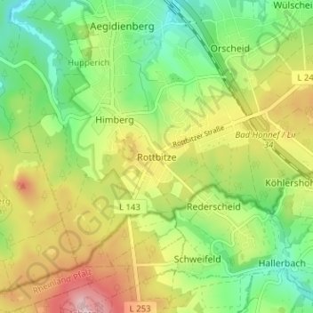
Name: Rottbitze topographic map, elevation, terrain.
Average elevation: 965 ft
Minimum elevation: 686 ft
Maximum elevation: 1,348 ft
Make a donation
Gear up for your next adventure:
As an Amazon Associate, this site earns from qualifying purchases at no extra cost to you.