Geolocate

Pirangut topographic map

Click on the map to display elevation.

About this map

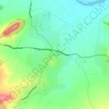
Name: Pirangut topographic map, elevation, terrain.

Location: Pirangut, Mulshi, Pune District, Maharashtra, 412115, India (18.49128 73.65901 18.53128 73.69901)

Average elevation: 1,969 ft

Minimum elevation: 1,821 ft

Maximum elevation: 2,306 ft

Other topographic maps

Click on a map to view its topography, its elevation and its terrain.

Aamby Valley

India > Maharashtra > Mulshi

Average elevation: 2,329 ft

Manas Lake

India > Maharashtra > Mulshi > Bhukum

Average elevation: 2,306 ft

Mulshi Lake

India > Maharashtra > Mulshi > Chachivali

Average elevation: 2,329 ft

Katarkhadak

India > Maharashtra > Mulshi

Average elevation: 2,657 ft

Mula

India > Maharashtra > Mulshi

Average elevation: 2,159 ft

Kasarsai

India > Maharashtra > Mulshi > Nere

Average elevation: 1,985 ft

Gear up for your next adventure:

🧷Carabiner Set - Durable clips for gear attachment
👟Trail Running Shoes - Lightweight shoes for trail runners
📦Dry Bags Set - Waterproof storage for electronics and clothes
🛠️Outdoor Gear Repair Kit - Essential tools to fix gear on the trail
🧢Sun Protection Hats - Wide-brimmed and UPF-rated hats for high-altitude sun safety

As an Amazon Associate, this site earns from qualifying purchases at no extra cost to you.