
Thank you for supporting this site ❤️
Make a donation
Make a donation
Gear up for your next adventure:
As an Amazon Associate, this site earns from qualifying purchases at no extra cost to you.
Lysebotn topographic map
Click on the map to display elevation.
Thank you for supporting this site ❤️
Make a donation
Make a donation
Gear up for your next adventure:
As an Amazon Associate, this site earns from qualifying purchases at no extra cost to you.
About this map
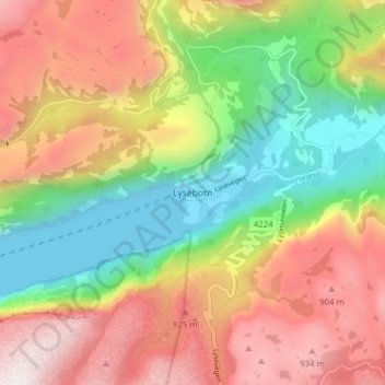
Name: Lysebotn topographic map, elevation, terrain.
Location: Lysebotn, Sandnes, Rogaland, 4127, Norway (59.03478 6.62687 59.07478 6.66687)
Average elevation: 1,640 ft
Minimum elevation: -20 ft
Maximum elevation: 3,478 ft
Thank you for supporting this site ❤️
Make a donation
Make a donation
Gear up for your next adventure:
As an Amazon Associate, this site earns from qualifying purchases at no extra cost to you.