
Thank you for supporting this site ❤️
Make a donation
Make a donation
Gear up for your next adventure:
As an Amazon Associate, this site earns from qualifying purchases at no extra cost to you.
Stefanago topographic map
Click on the map to display elevation.
Thank you for supporting this site ❤️
Make a donation
Make a donation
Gear up for your next adventure:
As an Amazon Associate, this site earns from qualifying purchases at no extra cost to you.
About this map
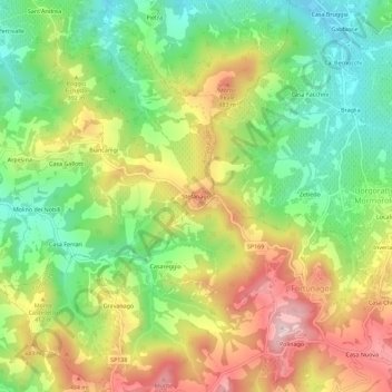
Name: Stefanago topographic map, elevation, terrain.
Location: Stefanago, Borgo Priolo, Pavia, Lombardia, Italia (44.91054 9.14744 44.95054 9.18744)
Average elevation: 1,152 ft
Minimum elevation: 633 ft
Maximum elevation: 1,818 ft
Thank you for supporting this site ❤️
Make a donation
Make a donation
Gear up for your next adventure:
As an Amazon Associate, this site earns from qualifying purchases at no extra cost to you.
Other topographic maps
Click on a map to view its topography, its elevation and its terrain.
Castello di Stefanago
Italia > Lombardia > Pavia > Borgo Priolo > Biancanigi
Average elevation: 1,194 ft