
Thank you for supporting this site ❤️
Make a donation
Make a donation
Gear up for your next adventure:
As an Amazon Associate, this site earns from qualifying purchases at no extra cost to you.
Fladungen topographic map
Click on the map to display elevation.
Thank you for supporting this site ❤️
Make a donation
Make a donation
Gear up for your next adventure:
As an Amazon Associate, this site earns from qualifying purchases at no extra cost to you.
About this map
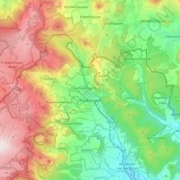
Name: Fladungen topographic map, elevation, terrain.
Average elevation: 1,785 ft
Minimum elevation: 1,043 ft
Maximum elevation: 2,881 ft
Thank you for supporting this site ❤️
Make a donation
Make a donation
Gear up for your next adventure:
As an Amazon Associate, this site earns from qualifying purchases at no extra cost to you.
Other topographic maps
Click on a map to view its topography, its elevation and its terrain.
Bad Neustadt an der Saale
Germany > Bavaria > Landkreis Rhön-Grabfeld > Bad Neustadt an der Saale
Average elevation: 938 ft