
Make a donation
Gear up for your next adventure:
As an Amazon Associate, this site earns from qualifying purchases at no extra cost to you.
Minneapolis topographic map
Click on the map to display elevation.
Make a donation
Gear up for your next adventure:
As an Amazon Associate, this site earns from qualifying purchases at no extra cost to you.
Minneapolis
A 1959 report by the U.S. Soil Conservation Service listed Minneapolis's elevation as 830 feet (250 m). The city's lowest elevation of 687 feet (209 m) above sea level is near where Minnehaha Creek meets the Mississippi River. Sources disagree on the exact location and elevation of the city's highest point, which is cited as being anywhere from 965–985 feet (294–300 m) above sea level.
Make a donation
Gear up for your next adventure:
As an Amazon Associate, this site earns from qualifying purchases at no extra cost to you.
About this map
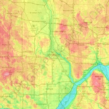
Name: Minneapolis topographic map, elevation, terrain.
Average elevation: 889 ft
Minimum elevation: 686 ft
Maximum elevation: 1,109 ft
Hennepin County trails, hiking, mountain biking, running and outdoor activities
Make a donation
Gear up for your next adventure:
As an Amazon Associate, this site earns from qualifying purchases at no extra cost to you.
Other topographic maps
Click on a map to view its topography, its elevation and its terrain.
Stevens Square - Loring Heights
United States > Minnesota > Hennepin County > Minneapolis
Average elevation: 873 ft
North Commons Park
United States > Minnesota > Hennepin County > Minneapolis
Average elevation: 876 ft
Make a donation
Gear up for your next adventure:
As an Amazon Associate, this site earns from qualifying purchases at no extra cost to you.