
Make a donation
Gear up for your next adventure:
As an Amazon Associate, this site earns from qualifying purchases at no extra cost to you.
Bedretto topographic map
Click on the map to display elevation.
Make a donation
Gear up for your next adventure:
As an Amazon Associate, this site earns from qualifying purchases at no extra cost to you.
Bedretto
1918 erteilte der Kanton Tessin die Genehmigung zum Abbau des Baukalkvorkommens auf der Alp Manió. Während und nach dem Ersten Weltkrieg bezog auch die Schweizer Industrie diesen Kalk, die ihn wegen des ungenügenden Reinheitsgrades vorher kaum berücksichtigt hatte. Auf der Alp Cavanna (2020 m ü. M.) bestand ein Specksteinbruch. Der Serpentin des Tals (Antigorit) ist grünlich. Der Rotondogranit ist bei Kletterern bekannt, weil er wegen der Höhe und Südlage flechtenfrei ist.
Make a donation
Gear up for your next adventure:
As an Amazon Associate, this site earns from qualifying purchases at no extra cost to you.
About this map
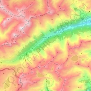
Name: Bedretto topographic map, elevation, terrain.
Average elevation: 7,382 ft
Minimum elevation: 3,750 ft
Maximum elevation: 10,295 ft
Make a donation
Gear up for your next adventure:
As an Amazon Associate, this site earns from qualifying purchases at no extra cost to you.
Other topographic maps
Click on a map to view its topography, its elevation and its terrain.
Nufenenpass
Schweiz > Tessin > Bezirk Leventina > Bedretto
Der Nufenenpass (italienisch Passo della Novena) ist ein 2439 m ü. M. hoher Gebirgspass in der Schweiz, der die Kantone Wallis im Westen und Tessin im Osten verbindet sowie die Gotthard-Gruppe im Norden von der Leone-Gruppe im Süden trennt. Über den Sattelpunkt verläuft der Vier-Quellen-Weg, die…
Average elevation: 7,959 ft