
Make a donation
Gear up for your next adventure:
As an Amazon Associate, this site earns from qualifying purchases at no extra cost to you.
Seyboldsdorf topographic map
Click on the map to display elevation.
Make a donation
Gear up for your next adventure:
As an Amazon Associate, this site earns from qualifying purchases at no extra cost to you.
Seyboldsdorf
Das Pfarrdorf Seyboldsdorf liegt gut drei Kilometer nördlich von Vilsbiburg auf einem Höhenrücken im Isar-Inn-Hügelland zwischen Großer und Kleiner Vils.
Make a donation
Gear up for your next adventure:
As an Amazon Associate, this site earns from qualifying purchases at no extra cost to you.
About this map
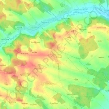
Name: Seyboldsdorf topographic map, elevation, terrain.
Average elevation: 1,542 ft
Minimum elevation: 1,427 ft
Maximum elevation: 1,654 ft
Make a donation
Gear up for your next adventure:
As an Amazon Associate, this site earns from qualifying purchases at no extra cost to you.
Other topographic maps
Click on a map to view its topography, its elevation and its terrain.
84137
Deutschland > Bayern > Landkreis Landshut > Vilsbiburg > Gaindorf > Berg
Average elevation: 1,493 ft