Geolocate

Visso topographic map

Click on the map to display elevation.

About this map

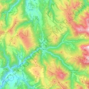
Name: Visso topographic map, elevation, terrain.

Location: Visso, Macerata, Marche, 62039, Italy (42.86858 12.94559 43.01068 13.15169)

Average elevation: 3,402 ft

Minimum elevation: 1,447 ft

Maximum elevation: 6,844 ft

Other topographic maps

Click on a map to view its topography, its elevation and its terrain.

Vecciola di Sopra

Italy > Marche > Macerata > Sarnano

Average elevation: 1,736 ft

San Martino

Italy > Marche > Macerata > Sant'Angelo in Pontano

Average elevation: 899 ft

Anselmi

Italy > Marche > Macerata > Monte San Martino

Average elevation: 1,329 ft

Aurora

Italy > Marche > Macerata > Civitanova Marche

Average elevation: 79 ft

Vestignano

Italy > Marche > Macerata > Caldarola

Average elevation: 2,067 ft

Gear up for your next adventure:

🔦Powerful Headlamps - Ultra-bright hands-free lighting for night navigation
🪶LED Camping Lantern - Bright lantern for camp lighting
📻Weather Alert Radios - Stay informed of storm risks while off-the-grid
🪶Camping Sleeping Pad - Comfortable sleeping pad for backpacking
👟Men's Trail Runners - Lightweight footwear for fast-paced exploration and light hiking

As an Amazon Associate, this site earns from qualifying purchases at no extra cost to you.