
Thank you for supporting this site ❤️
Make a donation
Make a donation
Gear up for your next adventure:
As an Amazon Associate, this site earns from qualifying purchases at no extra cost to you.
Esteli topographic map
Click on the map to display elevation.
Thank you for supporting this site ❤️
Make a donation
Make a donation
Gear up for your next adventure:
As an Amazon Associate, this site earns from qualifying purchases at no extra cost to you.
About this map
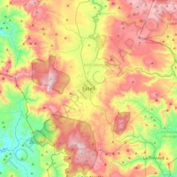
Name: Esteli topographic map, elevation, terrain.
Location: Esteli, Estelí (Municipio), Estelí, 31000, Nicaragua (12.93312 -86.51544 13.25312 -86.19544)
Average elevation: 3,071 ft
Minimum elevation: 1,178 ft
Maximum elevation: 5,194 ft
Thank you for supporting this site ❤️
Make a donation
Make a donation
Gear up for your next adventure:
As an Amazon Associate, this site earns from qualifying purchases at no extra cost to you.