
Pecos topographic map
Click on the map to display elevation.
About this map
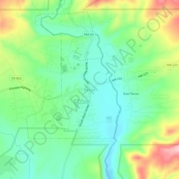
Name: Pecos topographic map, elevation, terrain.
Location: Pecos, San Miguel County, New Mexico, 87552, United States (35.55453 -105.69526 35.59453 -105.65526)
Average elevation: 7,041 ft
Minimum elevation: 6,827 ft
Maximum elevation: 7,457 ft
San Miguel County trails, hiking, mountain biking, running and outdoor activities
Other topographic maps
Click on a map to view its topography, its elevation and its terrain.
Pecos National Historic Park
United States > New Mexico > San Miguel County > Pecos
Average elevation: 7,346 ft