Geolocate

Bloomington topographic map

Click on the map to display elevation.

About this map

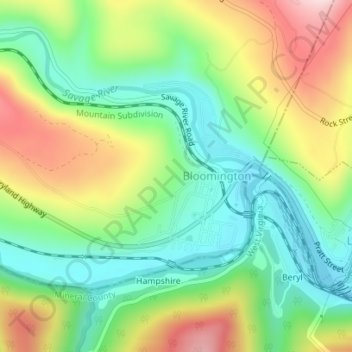
Name: Bloomington topographic map, elevation, terrain.

Location: Bloomington, Garrett County, Maryland, 21523, United States (39.47321 -79.08523 39.48684 -79.06774)

Average elevation: 1,329 ft

Minimum elevation: 932 ft

Maximum elevation: 1,955 ft

Garrett County trails, hiking, mountain biking, running and outdoor activities

Gear up for your next adventure:

🪶Thermal Camp Blanket - Extra warmth for cold nights
🪓Survival Multi‑Tool - Versatile tool for camp and trail tasks
🎒Waterproof Dry Bags - Keep your electronics and maps dry inside your pack
🔭Telescopic Hiking Pole - Adjustable pole for hiking stability
🧷Carabiner Set - Durable clips for gear attachment

As an Amazon Associate, this site earns from qualifying purchases at no extra cost to you.