Geolocate

Dexter topographic map

Click on the map to display elevation.

About this map

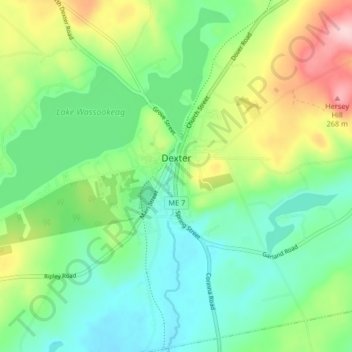
Name: Dexter topographic map, elevation, terrain.

Location: Dexter, Penobscot County, Maine, 04930, United States (44.98691 -69.35567 45.09018 -69.20852)

Average elevation: 509 ft

Minimum elevation: 266 ft

Maximum elevation: 1,040 ft

Other topographic maps

Click on a map to view its topography, its elevation and its terrain.

Bangor Hill

United States > Maine > Penobscot County > Orono

Average elevation: 203 ft

Hudson Hill

United States > Maine > Penobscot County > Hudson

Average elevation: 253 ft

Blackcap

United States > Maine > Penobscot County > Eddington

Average elevation: 571 ft

Sugar Island

United States > Maine > Penobscot County > Greenbush

Average elevation: 135 ft

Tiger Rips

United States > Maine > Penobscot County

Average elevation: 741 ft

State Island

United States > Maine > Penobscot County

Average elevation: 482 ft

Lincoln

United States > Maine > Penobscot County > Lincoln

Average elevation: 272 ft

Gear up for your next adventure:

🧣Merino Neck Gaiters - Multi-functional headwear for wind and sun protection
Camping Coffee Makers - Enjoy premium coffee at the summit or campsite
🪶Fire Starter Kit - Reliable fire starter for survival and camping
🌎3D Topographic Globes - Raised relief globes for a tactile understanding of geography
🗺️Topographic Maps - Detailed topo maps for hiking, exploring and outdoor navigation

As an Amazon Associate, this site earns from qualifying purchases at no extra cost to you.