Geolocate

Cazalla topographic map

Click on the map to display elevation.

About this map

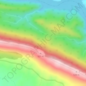
Name: Cazalla topographic map, elevation, terrain.

Location: Cazalla, Torrejón el Rubio, Cáceres, Extremadura, Spain (39.80391 -5.97199 39.82391 -5.95199)

Average elevation: 1,224 ft

Minimum elevation: 797 ft

Maximum elevation: 1,778 ft

Gear up for your next adventure:

🌡️Portable Weather Meter - Track weather conditions on the trail
🥄Camping Utensil Set - Lightweight utensils for outdoor meals
🧣Merino Neck Gaiters - Multi-functional headwear for wind and sun protection
🥤Water Filter Bottle - All‑in‑one filter bottle for safe hydration
🧺Microfiber Travel Towels - Compact and fast-drying towels for trail use

As an Amazon Associate, this site earns from qualifying purchases at no extra cost to you.