
Thank you for supporting this site ❤️
Make a donation
Make a donation
Gear up for your next adventure:
As an Amazon Associate, this site earns from qualifying purchases at no extra cost to you.
Rebordinho topographic map
Click on the map to display elevation.
Thank you for supporting this site ❤️
Make a donation
Make a donation
Gear up for your next adventure:
As an Amazon Associate, this site earns from qualifying purchases at no extra cost to you.
About this map
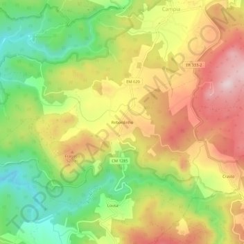
Name: Rebordinho topographic map, elevation, terrain.
Location: Rebordinho, Campia, Vouzela, Viseu, 3670-056, Portugal (40.63642 -8.24730 40.67642 -8.20730)
Average elevation: 1,414 ft
Minimum elevation: 804 ft
Maximum elevation: 2,037 ft
Thank you for supporting this site ❤️
Make a donation
Make a donation
Gear up for your next adventure:
As an Amazon Associate, this site earns from qualifying purchases at no extra cost to you.
Other topographic maps
Click on a map to view its topography, its elevation and its terrain.