
Lake Como topographic map
Click on the map to display elevation.
Lake Como
Lake Como weather is humid subtropical (Cfa in the Köppen climate classification). In the winter, the lake helps to maintain a higher temperature in the surrounding region. Average daily temperatures range from about 3.7 °C (39 °F) in January to 23.4 °C (74 °F) in July, according to historical weather data from Como. Water temperatures can reach an average of 24 °C (75 °F) during the month of July. Snowfall is erratic and primarily affects the higher elevations. Rainfall is heaviest in May and lowest during the winter months.
About this map
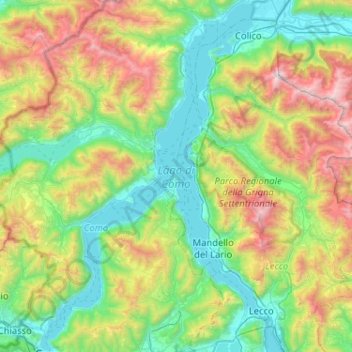
Name: Lake Como topographic map, elevation, terrain.
Location: Lake Como, Como, Lombardy, Italy (45.81316 9.06673 46.17036 9.38897)
Average elevation: 2,904 ft
Minimum elevation: 617 ft
Maximum elevation: 8,507 ft
Other topographic maps
Click on a map to view its topography, its elevation and its terrain.
Monte Bregagno
Italy > Lombardy > Como > Cremia
Monte Bregagno is a mountain of Lombardy, Italy, It has an elevation of 2,107 metres.
Average elevation: 5,538 ft