
Thank you for supporting this site ❤️
Make a donation
Make a donation
Gear up for your next adventure:
As an Amazon Associate, this site earns from qualifying purchases at no extra cost to you.
Casnedo topographic map
Click on the map to display elevation.
Thank you for supporting this site ❤️
Make a donation
Make a donation
Gear up for your next adventure:
As an Amazon Associate, this site earns from qualifying purchases at no extra cost to you.
About this map
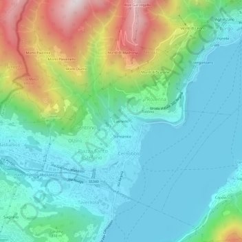
Name: Casnedo topographic map, elevation, terrain.
Location: Casnedo, Rovenna, Cernobbio, Como, Lombardy, 22026, Italy (45.82672 9.05394 45.86672 9.09394)
Average elevation: 1,427 ft
Minimum elevation: 633 ft
Maximum elevation: 3,625 ft
Thank you for supporting this site ❤️
Make a donation
Make a donation
Gear up for your next adventure:
As an Amazon Associate, this site earns from qualifying purchases at no extra cost to you.