Geolocate

Lacalm topographic map

Click on the map to display elevation.

Lacalm

La commune se situe au nord-ouest du plateau de l'Aubrac, au contact de la Viadène, sur les rivières Argence et Lebot. Sa superficie est de 2649 hectares (26,49 km2) à une altitude située entre 981 mètres et 1284 mètres.

Wikipedia (CC-BY-SA 3.0)

About this map

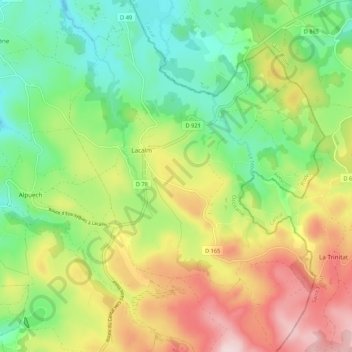
Name: Lacalm topographic map, elevation, terrain.

Location: Lacalm, Argences en Aubrac, Rodez, Aveyron, Occitanie, France métropolitaine, 12210, France (44.72845 2.86004 44.80430 2.93785)

Average elevation: 3,602 ft

Minimum elevation: 3,166 ft

Maximum elevation: 4,245 ft

Other topographic maps

Click on a map to view its topography, its elevation and its terrain.

Le Viala

France > Occitanie > Aveyron > Argences en Aubrac

Average elevation: 3,182 ft

Le Born

France > Occitanie > Aveyron > Argences en Aubrac

Average elevation: 3,127 ft

Les Clauzels

France > Occitanie > Aveyron > Argences en Aubrac

Average elevation: 3,094 ft

Le Cayrac

France > Occitanie > Aveyron > Argences en Aubrac

Average elevation: 3,074 ft

Le Batut

France > Occitanie > Aveyron > Argences en Aubrac

Average elevation: 2,838 ft

Gear up for your next adventure:

📶Vehicle Signal Boosters - Improve reception in rural areas while driving to trailheads
🗃️Trail First Aid Kit - Essential kit for outdoor injuries and emergencies
GPS Sports Watch - GPS watch for running, hiking and training
📚Navigation Handbooks - Master the art of reading topographic maps and using a compass
🪶LED Camping Lantern - Bright lantern for camp lighting

As an Amazon Associate, this site earns from qualifying purchases at no extra cost to you.