Geolocate

Chumukedima topographic map

Click on the map to display elevation.

About this map

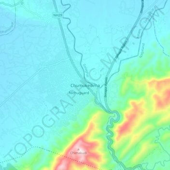
Name: Chumukedima topographic map, elevation, terrain.

Location: Chumukedima, Chümoukedima, Nagaland, 797103, India (25.76903 93.74812 25.84903 93.82812)

Average elevation: 823 ft

Minimum elevation: 525 ft

Maximum elevation: 2,415 ft

Gear up for your next adventure:

📻Weather Alert Radios - Stay informed of storm risks while off-the-grid
GPS Sports Watch - GPS watch for running, hiking and training
⛑️Personal Locator Beacon - Safety beacon for emergencies
📦Gear Storage Bags - Organize and protect outdoor equipment
🔪Outdoor Multitools - Essential survival tools for gear repair and field use

As an Amazon Associate, this site earns from qualifying purchases at no extra cost to you.