
Make a donation
Gear up for your next adventure:
As an Amazon Associate, this site earns from qualifying purchases at no extra cost to you.
Opladen topographic map
Click on the map to display elevation.
Make a donation
Gear up for your next adventure:
As an Amazon Associate, this site earns from qualifying purchases at no extra cost to you.
Opladen
Der damalige Landrat des Landkreises Solingen, Adolf Lucas, förderte wesentlich die 1906 erfolgte Gründung der Paritätischen höhere Knabenschule Opladen, des heutigen Landrat-Lucas-Gymnasiums, für die 1911 ein neues Gebäude im Hederichsfeld errichtet wurde. Lucas veranlasste auch den Umzug der Kreisverwaltung des Landkreises Solingen von Solingen nach Opladen im Jahre 1914, nachdem Solingen bereits seit einigen Jahren kreisfrei gewesen war. Im selben Jahr wurde die von ihm geförderte Landwirtschaftsschule des unteren Kreises Solingen in Opladen eröffnet. 1907 wurde der repräsentative Neubau des Erzbischöflichen Aloysianums eröffnet, der das Stadtbild Opladens bis zum Abriss 1975 prägte, zuletzt als Opladener Rathaus.
Make a donation
Gear up for your next adventure:
As an Amazon Associate, this site earns from qualifying purchases at no extra cost to you.
About this map
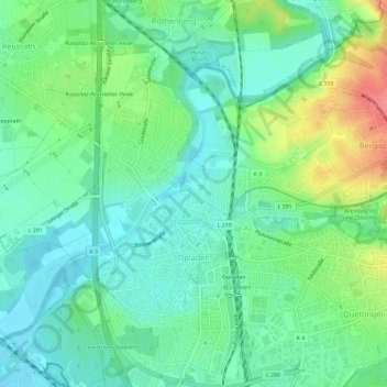
Name: Opladen topographic map, elevation, terrain.
Average elevation: 217 ft
Minimum elevation: 141 ft
Maximum elevation: 387 ft
Make a donation
Gear up for your next adventure:
As an Amazon Associate, this site earns from qualifying purchases at no extra cost to you.
Other topographic maps
Click on a map to view its topography, its elevation and its terrain.
Make a donation
Gear up for your next adventure:
As an Amazon Associate, this site earns from qualifying purchases at no extra cost to you.