
Make a donation
Gear up for your next adventure:
As an Amazon Associate, this site earns from qualifying purchases at no extra cost to you.
Ourika topographic map
Click on the map to display elevation.
Make a donation
Gear up for your next adventure:
As an Amazon Associate, this site earns from qualifying purchases at no extra cost to you.
About this map
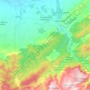
Name: Ourika topographic map, elevation, terrain.
Average elevation: 3,967 ft
Minimum elevation: 2,431 ft
Maximum elevation: 7,372 ft
Make a donation
Gear up for your next adventure:
As an Amazon Associate, this site earns from qualifying purchases at no extra cost to you.
Other topographic maps
Click on a map to view its topography, its elevation and its terrain.
Oukaïmeden
Morocco > Marrakech-Safi > Cercle de Tahannaout دائرة تحناوت > Oukaimeden
The skiing area is at an altitude of between 2,600 metres (8,500 ft) and 3,200 metres (10,500 ft) and has six ski lifts. There are some hotels and ski rental facilities nearby. Recently oukaimeden is more known of it’s Bouldering potential then the skiing possibilities.
Average elevation: 7,946 ft
Tizert
Morocco > Marrakech-Safi > Cercle de Tahannaout دائرة تحناوت > Sti Fadma
Average elevation: 4,770 ft