
Make a donation
Gear up for your next adventure:
As an Amazon Associate, this site earns from qualifying purchases at no extra cost to you.
Aarschot topographic map
Click on the map to display elevation.
Make a donation
Gear up for your next adventure:
As an Amazon Associate, this site earns from qualifying purchases at no extra cost to you.
Aarschot
Een andere verklaring vertrekt van de eerste schriftelijke vermelding van Aarschot in 1107 als Arescod. Deze naam is afgeleid van de Germaanse woorden "arnu" (= arend, dit kan eventueel ook verwijzen naar een persoonsnaam) en "skauta" (= bebost stuk hoger gelegen land, uitspringend in een moerassig terrein). Deze verklaring past ook perfect in de Aarschotse topografie.
Make a donation
Gear up for your next adventure:
As an Amazon Associate, this site earns from qualifying purchases at no extra cost to you.
About this map
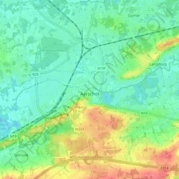
Name: Aarschot topographic map, elevation, terrain.
Location: Aarschot, Leuven, Vlaams-Brabant, Vlaanderen, België (50.95810 4.80040 51.01310 4.87061)
Average elevation: 85 ft
Minimum elevation: 13 ft
Maximum elevation: 230 ft
Make a donation
Gear up for your next adventure:
As an Amazon Associate, this site earns from qualifying purchases at no extra cost to you.
Other topographic maps
Click on a map to view its topography, its elevation and its terrain.