
Make a donation
Gear up for your next adventure:
As an Amazon Associate, this site earns from qualifying purchases at no extra cost to you.
Heubach topographic map
Click on the map to display elevation.
Make a donation
Gear up for your next adventure:
As an Amazon Associate, this site earns from qualifying purchases at no extra cost to you.
About this map
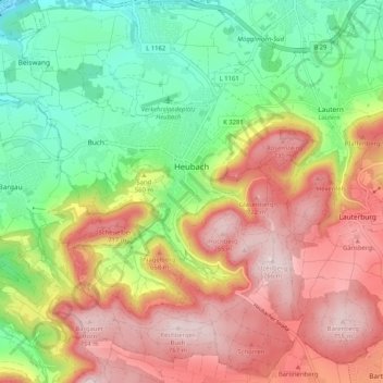
Name: Heubach topographic map, elevation, terrain.
Average elevation: 1,818 ft
Minimum elevation: 1,188 ft
Maximum elevation: 2,530 ft
Make a donation
Gear up for your next adventure:
As an Amazon Associate, this site earns from qualifying purchases at no extra cost to you.
Other topographic maps
Click on a map to view its topography, its elevation and its terrain.
Wilflingen
Germany > Baden-Württemberg > Ostalbkreis > Abtsgmünd
The main town of Abtsgmünd lies at the confluence of the Lein river into the Kocher (confluence elevation 367.4 m above sea level), predominantly on the left bank of the Kocher and left bank of the Lein. The furthest district of Untergröningen lies over 8 km west-northwest as the crow flies along two river…
Average elevation: 1,417 ft
Kapfenburg
Germany > Baden-Württemberg > Ostalbkreis > Lauchheim > Domäne Kapfenburg
Average elevation: 1,834 ft
Make a donation
Gear up for your next adventure:
As an Amazon Associate, this site earns from qualifying purchases at no extra cost to you.