
Make a donation
Gear up for your next adventure:
As an Amazon Associate, this site earns from qualifying purchases at no extra cost to you.
Tête du Rouget topographic map
Click on the map to display elevation.
Make a donation
Gear up for your next adventure:
As an Amazon Associate, this site earns from qualifying purchases at no extra cost to you.
About this map
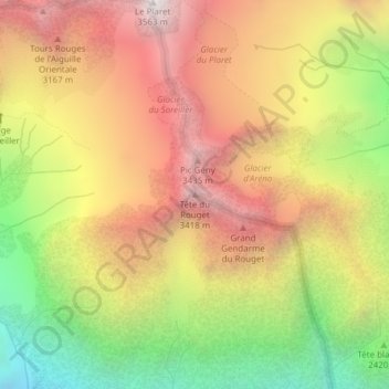
Name: Tête du Rouget topographic map, elevation, terrain.
Average elevation: 9,006 ft
Minimum elevation: 5,902 ft
Maximum elevation: 11,670 ft
Make a donation
Gear up for your next adventure:
As an Amazon Associate, this site earns from qualifying purchases at no extra cost to you.
Other topographic maps
Click on a map to view its topography, its elevation and its terrain.
Glacier de la Selle
France > Auvergne-Rhône-Alpes > Isère > Saint-Christophe-en-Oisans
Average elevation: 10,203 ft
Glacier du Fond
France > Auvergne-Rhône-Alpes > Isère > Saint-Christophe-en-Oisans
Average elevation: 9,350 ft
Glacier de la Pilatte
France > Auvergne-Rhône-Alpes > Isère > Saint-Christophe-en-Oisans
Average elevation: 9,774 ft