Geolocate

Mambuaya topographic map

Click on the map to display elevation.

About this map

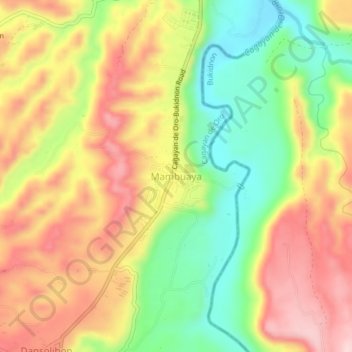
Name: Mambuaya topographic map, elevation, terrain.

Location: Mambuaya, Cagayan de Oro, Northern Mindanao, 9000, Philippines (8.30763 124.57772 8.34763 124.61772)

Average elevation: 666 ft

Minimum elevation: 230 ft

Maximum elevation: 1,079 ft

Other topographic maps

Click on a map to view its topography, its elevation and its terrain.

Divisoria Plaza

Philippines > Cagayan de Oro

Average elevation: 36 ft

Gaston Park

Philippines > Cagayan de Oro

Average elevation: 43 ft

Rodelsa Circle

Philippines > Cagayan de Oro

Average elevation: 62 ft

Iponan River

Philippines > Cagayan de Oro

Average elevation: 240 ft

Xavier Heights

Philippines > Cagayan de Oro

Average elevation: 315 ft

Calaanan Creek

Philippines > Cagayan de Oro

Average elevation: 230 ft

Divisoria Plaza

Philippines > Cagayan de Oro

Average elevation: 36 ft

Rodelsa Circle

Philippines > Cagayan de Oro

Average elevation: 62 ft

Gear up for your next adventure:

🧢Sun Protection Hats - Wide-brimmed and UPF-rated hats for high-altitude sun safety
🌄Hiking Binoculars - Compact binoculars for scenic views and trail spotting
🏕️Tent Footprint - Protect your tent base from wear
🔥Fast-Boil Camping Stoves - Efficient cooking systems for quick trail meals
🩹Survival Bandages - High‑quality bandages for emergencies

As an Amazon Associate, this site earns from qualifying purchases at no extra cost to you.