Geolocate

Nicholson Estates topographic map

Click on the map to display elevation.

About this map

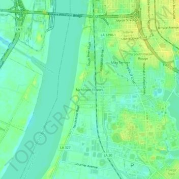
Name: Nicholson Estates topographic map, elevation, terrain.

Location: Nicholson Estates, Baton Rouge, East Baton Rouge Parish, Louisiana, 70803, United States (30.40269 -91.21094 30.44269 -91.17094)

Average elevation: 36 ft

Minimum elevation: 7 ft

Maximum elevation: 72 ft

East Baton Rouge Parish trails, hiking, mountain biking, running and outdoor activities

Other topographic maps

Click on a map to view its topography, its elevation and its terrain.

Gear up for your next adventure:

🧣Hiking Neck Gaiter - Multi‑use neck protection for outdoor weather
Camping Coffee Makers - Enjoy premium coffee at the summit or campsite
🛠️Backpacking Tool Kit - Essential toolkit for outdoor repairs
🔥Camping Stove - Portable stove for camping and backcountry cooking
🔦Powerful Headlamps - Ultra-bright hands-free lighting for night navigation

As an Amazon Associate, this site earns from qualifying purchases at no extra cost to you.