Geolocate

Ulsoor Lake topographic map

Click on the map to display elevation.

About this map

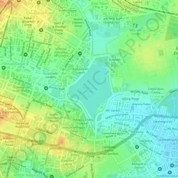
Name: Ulsoor Lake topographic map, elevation, terrain.

Location: Ulsoor Lake, K Kamaraj Ward, Bengaluru Central City Corporation, Bengaluru, Bangalore North, Bengaluru Urban, Karnataka, 560042, India (12.97744 77.61585 12.98751 77.62275)

Average elevation: 2,969 ft

Minimum elevation: 2,910 ft

Maximum elevation: 3,038 ft

Other topographic maps

Click on a map to view its topography, its elevation and its terrain.

Nagawara Lake

India > Karnataka > Bangalore North > Bengaluru

Average elevation: 2,940 ft

Nagarbhavi Lake

India > Karnataka > Bangalore North > Bengaluru

Average elevation: 2,799 ft

Cubbon Park

India > Karnataka > Bangalore North > Bengaluru

Average elevation: 3,009 ft

HRBR Layout

India > Karnataka > Bangalore North > Bengaluru

Average elevation: 2,936 ft

Banni Mantapa

India > Karnataka > Bangalore North > Bengaluru

Average elevation: 2,894 ft

Bugle Rock Park

India > Karnataka > Bangalore North > Bengaluru

Average elevation: 2,979 ft

Bangalore Palace

India > Karnataka > Bangalore North > Bengaluru

Average elevation: 3,041 ft

Madhavan Park

India > Karnataka > Bangalore North > Bengaluru

Average elevation: 3,005 ft

Thirumenahalli

India > Karnataka > Bangalore North > Bengaluru > Thirumenahalli

Average elevation: 2,979 ft

Nagawara Lake

India > Karnataka > Bangalore North > Bengaluru

Average elevation: 2,940 ft

Gear up for your next adventure:

🦶Carbon Trekking Poles - Reduce knee impact on steep descents with ultra-light poles
🔥Fast-Boil Camping Stoves - Efficient cooking systems for quick trail meals
🪓Survival Multi‑Tool - Versatile tool for camp and trail tasks
🧦Hiking Socks - Comfortable socks to prevent blisters on long hikes
🚗GPS Dash Cams - Record your scenic drives through mountain passes and canyons

As an Amazon Associate, this site earns from qualifying purchases at no extra cost to you.