Geolocate

Lek topographic map

Click on the map to display elevation.

About this map

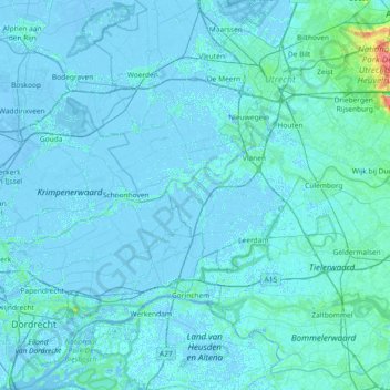
Name: Lek topographic map, elevation, terrain.

Location: Lek, Utrecht, Netherlands (51.88931 4.61747 52.00298 5.35247)

Average elevation: 3 ft

Minimum elevation: -26 ft

Maximum elevation: 177 ft

Other topographic maps

Click on a map to view its topography, its elevation and its terrain.

Amersfoortse Berg

Netherlands > Utrecht > Amersfoort

Average elevation: 62 ft

Cabauw

Netherlands > Utrecht

Average elevation: -3 ft

Palestina

Netherlands > Utrecht > Amersfoort

Average elevation: 7 ft

Breedeveen

Netherlands > Utrecht > Leersum

Average elevation: 49 ft

Amerongse Berg

Netherlands > Utrecht > Amerongen

Average elevation: 112 ft

Eembrugge

Netherlands > Utrecht > Baarn

Average elevation: 3 ft

Graaf

Netherlands > Utrecht > Lopik

Average elevation: 0 ft

Gear up for your next adventure:

🥇GPS Hiking Watch - Multi‑sport GPS watch with navigation and trail tracking
🎒Day Hiking Backpack - Lightweight backpack perfect for day trips and outdoor adventures
🪶Fire Starter Kit - Reliable fire starter for survival and camping
🧭Compass with Lanyard - Easy‑carry compass for navigation
🩹Survival Bandages - High‑quality bandages for emergencies

As an Amazon Associate, this site earns from qualifying purchases at no extra cost to you.