Geolocate

Benhaan topographic map

Click on the map to display elevation.

About this map

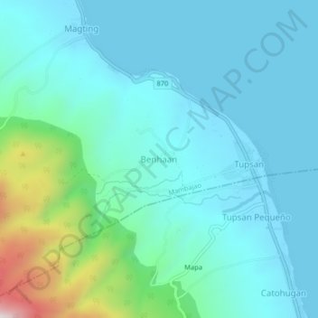
Name: Benhaan topographic map, elevation, terrain.

Location: Benhaan, Mambajao, Camiguin, Northern Mindanao, 9100, Philippines (9.18243 124.74591 9.22243 124.78591)

Average elevation: 410 ft

Minimum elevation: -3 ft

Maximum elevation: 2,434 ft

Other topographic maps

Click on a map to view its topography, its elevation and its terrain.

Camiguin

Philippines > Camiguin > Mambajao

Camiguin Island is a pearl-shaped island with an area of approximately 238 km2 (92 sq mi). The island measures about 23 kilometres (14 mi) at its longest and 14.5 kilometres (9.0 mi) at its widest breadth. The island is mountainous with the highest elevation reaching over 5,000 ft (1,500 m). It is encircled by…

Average elevation: 679 ft

Medano Islet

Philippines > Camiguin > Mambajao

Average elevation: 0 ft

Gear up for your next adventure:

🪑Ultralight Camp Chairs - Portable seating for resting after a long day of mapping
🚗GPS Dash Cams - Record your scenic drives through mountain passes and canyons
🎒Day Hiking Backpack - Lightweight backpack perfect for day trips and outdoor adventures
🔭Compact Binoculars - HD vision for scouting terrain and identifying distant landmarks
🏕️Family Camping Gear - Essentials for group camping trips

As an Amazon Associate, this site earns from qualifying purchases at no extra cost to you.