
Make a donation
Gear up for your next adventure:
As an Amazon Associate, this site earns from qualifying purchases at no extra cost to you.
Veredas da Cidade topographic map
Click on the map to display elevation.
Make a donation
Gear up for your next adventure:
As an Amazon Associate, this site earns from qualifying purchases at no extra cost to you.
About this map
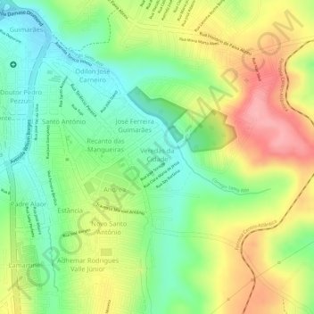
Name: Veredas da Cidade topographic map, elevation, terrain.
Average elevation: 3,327 ft
Minimum elevation: 3,140 ft
Maximum elevation: 3,547 ft
Make a donation
Gear up for your next adventure:
As an Amazon Associate, this site earns from qualifying purchases at no extra cost to you.
Other topographic maps
Click on a map to view its topography, its elevation and its terrain.
Araxá
Brasil > Minas Gerais > Araxá
Constituído de terras planas e colinas, a altitude máxima é de 1.359 metros e a mínima de 910 metros. O relevo do município mostra variações entre situações geológicas típicas do cerrado e de serras. Sua vegetação intercala campos de pastagens com pequenas matas naturais, compondo paisagens deslumbrantes.
Average elevation: 3,294 ft