Geolocate

Cerceda topographic map

Click on the map to display elevation.

About this map

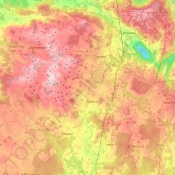
Name: Cerceda topographic map, elevation, terrain.

Location: Cerceda, Ordes, A Coruña, Galicia, Spain (43.09889 -8.59686 43.22652 -8.39606)

Average elevation: 1,194 ft

Minimum elevation: 62 ft

Maximum elevation: 1,939 ft

Other topographic maps

Click on a map to view its topography, its elevation and its terrain.

Hospital

Spain > Galicia > Ordes

Average elevation: 1,325 ft

Cruz de Nouche

Spain > Galicia > Ordes > Beán

Average elevation: 1,024 ft

Meitufe do Medio

Spain > Galicia > Ordes > Ordes

Average elevation: 1,257 ft

O Canedo

Spain > Galicia > Ordes

Average elevation: 1,234 ft

Gear up for your next adventure:

🪶Multi‑Purpose Knife - Useful blade for camp and trail
🍳Camping Cook Set - Complete cookware for outdoor meals
🧤Tactile Hiking Gloves - Keep hands warm while operating GPS and smartphone screens
🌧️Backpack Rain Cover - Keep gear dry in wet weather
🏔️Mountain Trail Maps - High‑detail maps for popular peaks

As an Amazon Associate, this site earns from qualifying purchases at no extra cost to you.