
Make a donation
Gear up for your next adventure:
As an Amazon Associate, this site earns from qualifying purchases at no extra cost to you.
Gotarta topographic map
Click on the map to display elevation.
Make a donation
Gear up for your next adventure:
As an Amazon Associate, this site earns from qualifying purchases at no extra cost to you.
Gotarta
Está situado a 1195 metros de altitud, entre el barranco de Raons y el barranco de l'Oratori. La población era de 30 habitantes en 1970.
Make a donation
Gear up for your next adventure:
As an Amazon Associate, this site earns from qualifying purchases at no extra cost to you.
About this map
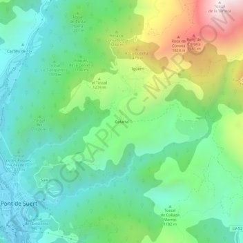
Name: Gotarta topographic map, elevation, terrain.
Location: Gotarta, Pont de Suert, Alta Ribagorza, Cataluña, 25520, España (42.40143 0.74382 42.44143 0.78382)
Average elevation: 3,750 ft
Minimum elevation: 2,717 ft
Maximum elevation: 6,112 ft
Make a donation
Gear up for your next adventure:
As an Amazon Associate, this site earns from qualifying purchases at no extra cost to you.