
Thank you for supporting this site ❤️
Make a donation
Make a donation
Gear up for your next adventure:
As an Amazon Associate, this site earns from qualifying purchases at no extra cost to you.
Poulo topographic map
Click on the map to display elevation.
Thank you for supporting this site ❤️
Make a donation
Make a donation
Gear up for your next adventure:
As an Amazon Associate, this site earns from qualifying purchases at no extra cost to you.
About this map
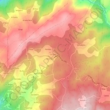
Name: Poulo topographic map, elevation, terrain.
Location: Poulo, Gomesende, Tierra de Celanova, Orense, Galicia, España (42.18145 -8.11439 42.22371 -8.07322)
Average elevation: 1,453 ft
Minimum elevation: 492 ft
Maximum elevation: 1,939 ft
Thank you for supporting this site ❤️
Make a donation
Make a donation
Gear up for your next adventure:
As an Amazon Associate, this site earns from qualifying purchases at no extra cost to you.