
Make a donation
Gear up for your next adventure:
As an Amazon Associate, this site earns from qualifying purchases at no extra cost to you.
Grömitz topographic map
Click on the map to display elevation.
Make a donation
Gear up for your next adventure:
As an Amazon Associate, this site earns from qualifying purchases at no extra cost to you.
About this map
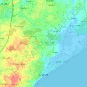
Name: Grömitz topographic map, elevation, terrain.
Location: Grömitz, Kreis Ostholstein, Schleswig-Holstein, 23743, Germany (54.13286 10.88730 54.22268 11.04840)
Average elevation: 49 ft
Minimum elevation: -26 ft
Maximum elevation: 187 ft
Make a donation
Gear up for your next adventure:
As an Amazon Associate, this site earns from qualifying purchases at no extra cost to you.
Other topographic maps
Click on a map to view its topography, its elevation and its terrain.
Pelzerhaken
Germany > Schleswig-Holstein > Kreis Ostholstein > Neustadt in Holstein
Average elevation: 26 ft
Make a donation
Gear up for your next adventure:
As an Amazon Associate, this site earns from qualifying purchases at no extra cost to you.