Geolocate

Colfax topographic map

Click on the map to display elevation.

About this map

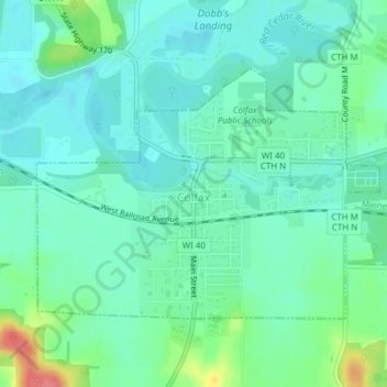
Name: Colfax topographic map, elevation, terrain.

Location: Colfax, Dunn County, Wisconsin, United States (44.99027 -91.74279 45.00769 -91.70893)

Average elevation: 955 ft

Minimum elevation: 896 ft

Maximum elevation: 1,135 ft

Dunn County trails, hiking, mountain biking, running and outdoor activities

Other topographic maps

Click on a map to view its topography, its elevation and its terrain.

Cedar Falls

United States > Wisconsin > Dunn County

Average elevation: 899 ft

Mount Fuji

United States > Wisconsin > Dunn County

Average elevation: 1,027 ft

Mount Fuji

United States > Wisconsin > Dunn County

Average elevation: 1,027 ft

Graytown

United States > Wisconsin > Dunn County

Average elevation: 1,129 ft

Canary Island

United States > Wisconsin > Dunn County > Menomonie

Average elevation: 860 ft

Gear up for your next adventure:

🛠️Backpacking Tool Kit - Essential toolkit for outdoor repairs
👖Convertible Hiking Pants - Versatile zip-off pants for changing altitudes and temperatures
🔭Telescopic Hiking Pole - Adjustable pole for hiking stability
🦶Carbon Trekking Poles - Reduce knee impact on steep descents with ultra-light poles
🔪Outdoor Multitools - Essential survival tools for gear repair and field use

As an Amazon Associate, this site earns from qualifying purchases at no extra cost to you.