
Make a donation
Gear up for your next adventure:
As an Amazon Associate, this site earns from qualifying purchases at no extra cost to you.
Olinda topographic map
Click on the map to display elevation.
Make a donation
Gear up for your next adventure:
As an Amazon Associate, this site earns from qualifying purchases at no extra cost to you.
Olinda
A altitude média do município é de dezesseis metros acima do nível do mar. O relevo é formado por planícies e colinas, algumas delas íngremes. Olinda possui a maior parte de seu território na bacia hidrográfica do rio Paratibe (55,13%) e o restante na bacia do rio Capibaribe (44,87%). A vegetação é formada por Mata Atlântica, com espécies de grande porte.
Make a donation
Gear up for your next adventure:
As an Amazon Associate, this site earns from qualifying purchases at no extra cost to you.
About this map
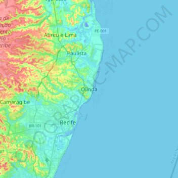
Name: Olinda topographic map, elevation, terrain.
Average elevation: 62 ft
Minimum elevation: -62 ft
Maximum elevation: 436 ft
Make a donation
Gear up for your next adventure:
As an Amazon Associate, this site earns from qualifying purchases at no extra cost to you.
Other topographic maps
Click on a map to view its topography, its elevation and its terrain.
Alto da Conquista
Brasil > Pernambuco > Região Metropolitana do Recife > Olinda
Average elevation: 151 ft
Make a donation
Gear up for your next adventure:
As an Amazon Associate, this site earns from qualifying purchases at no extra cost to you.
Centro Histórico da Cidade de Olinda
Brasil > Pernambuco > Região Metropolitana do Recife > Olinda
Average elevation: 36 ft
Make a donation
Gear up for your next adventure:
As an Amazon Associate, this site earns from qualifying purchases at no extra cost to you.
Make a donation
Gear up for your next adventure:
As an Amazon Associate, this site earns from qualifying purchases at no extra cost to you.
Alto do Sol Nascente
Brasil > Pernambuco > Região Metropolitana do Recife > Olinda
Average elevation: 157 ft
Jardim Atlântico
Brasil > Pernambuco > Região Metropolitana do Recife > Olinda
Average elevation: 36 ft
Make a donation
Gear up for your next adventure:
As an Amazon Associate, this site earns from qualifying purchases at no extra cost to you.
Reserva de Floresta Urbana Mata do Passarinho
Brasil > Pernambuco > Região Metropolitana do Recife > Olinda > Passarinho
Average elevation: 125 ft