
Make a donation
Gear up for your next adventure:
As an Amazon Associate, this site earns from qualifying purchases at no extra cost to you.
Morro da Palha topographic map
Click on the map to display elevation.
Make a donation
Gear up for your next adventure:
As an Amazon Associate, this site earns from qualifying purchases at no extra cost to you.
About this map
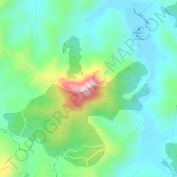
Name: Morro da Palha topographic map, elevation, terrain.
Average elevation: 2,795 ft
Minimum elevation: 2,493 ft
Maximum elevation: 3,514 ft
Make a donation
Gear up for your next adventure:
As an Amazon Associate, this site earns from qualifying purchases at no extra cost to you.
Other topographic maps
Click on a map to view its topography, its elevation and its terrain.
Ouro Fino de Baixo
Brasil > Paraná > Região Metropolitana de Curitiba > Campo Magro
Average elevation: 2,917 ft
Campo da Cascavel
Brasil > Paraná > Região Metropolitana de Curitiba > Campo Magro
Average elevation: 2,782 ft
Rio Passaúna
Brasil > Paraná > Região Metropolitana de Curitiba > Campo Magro
Average elevation: 3,120 ft