Geolocate

Nazira topographic map

Click on the map to display elevation.

About this map

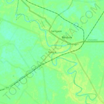
Name: Nazira topographic map, elevation, terrain.

Location: Nazira, Sivasagar, Assam, 785685, India (26.87655 94.69739 26.95655 94.77739)

Average elevation: 318 ft

Minimum elevation: 295 ft

Maximum elevation: 338 ft

Gear up for your next adventure:

🪶Camping Sleeping Pad - Comfortable sleeping pad for backpacking
🪶Compact Camp Shovel - Folding shovel for campsite tasks
🪶Thermal Camp Blanket - Extra warmth for cold nights
🧯Emergency Survival Kit - All‑in‑one survival essentials for the backcountry
🦶Hiking Gaiters - Keep debris and water out of your boots

As an Amazon Associate, this site earns from qualifying purchases at no extra cost to you.