
Make a donation
Gear up for your next adventure:
As an Amazon Associate, this site earns from qualifying purchases at no extra cost to you.
Wittgendorf topographic map
Click on the map to display elevation.
Make a donation
Gear up for your next adventure:
As an Amazon Associate, this site earns from qualifying purchases at no extra cost to you.
Wittgendorf
Ein weiterer Weiler aus Bauerngütern sind die Wittgendorfer Feldhäuser, die zwischen Wittgendorf und Dittelsdorf liegen. Ein alter Name der Siedlung war Wittgendorfer Neufelder. Die hier erbauten Vierseithöfe weisen darauf hin, dass die umgebenden Felder besonders fruchtbar sind. Topographische Karten aus dem 19. Jahrhundert deuten auf eine Windmühle hin und durch den Namen eines Geländeabfalls vermutet man, dass hier früher Hopfen angebaut wurde. Auch hier wurde 1952 eine LPG gegründet, die sich 1965 der Wittgendorfer Genossenschaft anschloss.
Make a donation
Gear up for your next adventure:
As an Amazon Associate, this site earns from qualifying purchases at no extra cost to you.
About this map
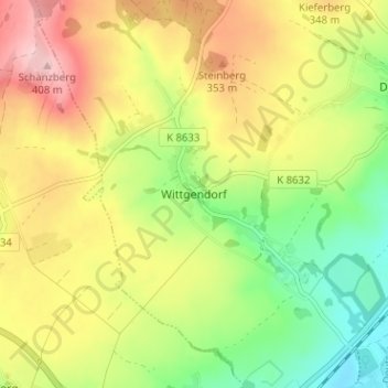
Name: Wittgendorf topographic map, elevation, terrain.
Average elevation: 1,017 ft
Minimum elevation: 725 ft
Maximum elevation: 1,339 ft
Make a donation
Gear up for your next adventure:
As an Amazon Associate, this site earns from qualifying purchases at no extra cost to you.
Other topographic maps
Click on a map to view its topography, its elevation and its terrain.