
Make a donation
Gear up for your next adventure:
As an Amazon Associate, this site earns from qualifying purchases at no extra cost to you.
Yanacachi topographic map
Click on the map to display elevation.
Make a donation
Gear up for your next adventure:
As an Amazon Associate, this site earns from qualifying purchases at no extra cost to you.
About this map
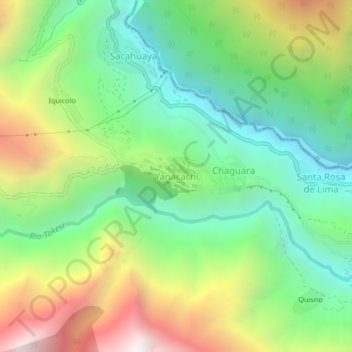
Name: Yanacachi topographic map, elevation, terrain.
Average elevation: 6,490 ft
Minimum elevation: 4,472 ft
Maximum elevation: 9,875 ft
Make a donation
Gear up for your next adventure:
As an Amazon Associate, this site earns from qualifying purchases at no extra cost to you.
Other topographic maps
Click on a map to view its topography, its elevation and its terrain.
Represa de Cacapi
Bolivia > La Paz > Provincia Sud Yungas > Municipio Yanacachi
Average elevation: 9,701 ft
Rio Chillata
Bolivia > La Paz > Provincia Sud Yungas > Municipio Yanacachi
Average elevation: 9,393 ft
Puente Villa
Bolivia > La Paz > Provincia Sud Yungas > Municipio Yanacachi
Average elevation: 4,934 ft