Geolocate

Wörleschwang topographic map

Click on the map to display elevation.

About this map

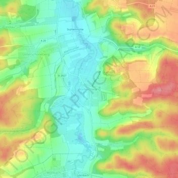
Name: Wörleschwang topographic map, elevation, terrain.

Location: Wörleschwang, Zusmarshausen, Landkreis Augsburg, Bayern, 86441, Deutschland (48.41620 10.57819 48.45620 10.61819)

Average elevation: 1,565 ft

Minimum elevation: 1,417 ft

Maximum elevation: 1,755 ft

Other topographic maps

Click on a map to view its topography, its elevation and its terrain.

86441

Deutschland > Bayern > Landkreis Augsburg > Zusmarshausen > Wollbach > Vallried

Average elevation: 1,568 ft

Gear up for your next adventure:

🌄Hiking Binoculars - Compact binoculars for scenic views and trail spotting
📱Heavy-Duty Phone Cases - Drop-proof and waterproof protection for outdoor navigation
🔦Compact Flashlight - Reliable flashlight for emergencies
🎁Geography Themed Gifts - Unique gift ideas for map lovers and geography enthusiasts
🪶Camp Gear Gift Set - Perfect gift bundle for outdoor fans

As an Amazon Associate, this site earns from qualifying purchases at no extra cost to you.