Geolocate

Geratag topographic map

Click on the map to display elevation.

About this map

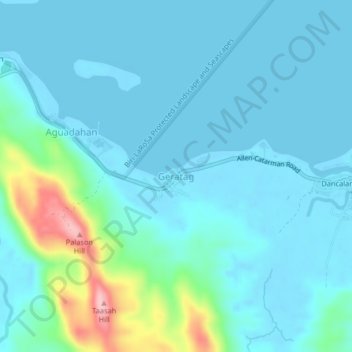
Name: Geratag topographic map, elevation, terrain.

Location: Geratag, Northern Samar, Eastern Visayas, 6402, Philippines (12.49952 124.49398 12.53952 124.53398)

Average elevation: 85 ft

Minimum elevation: -10 ft

Maximum elevation: 561 ft

Gear up for your next adventure:

🧭Outdoor Navigation Book - Learn advanced navigation skills
🔪Outdoor Multitools - Essential survival tools for gear repair and field use
📻Weather Alert Radios - Stay informed of storm risks while off-the-grid
🥘Titanium Cookware - Durable, featherlight pots and pans for backpacking
🔦Powerful Headlamps - Ultra-bright hands-free lighting for night navigation

As an Amazon Associate, this site earns from qualifying purchases at no extra cost to you.