Geolocate

Huntingburg topographic map

Interactive map

Click on the map to display elevation.

About this map

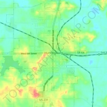
Name: Huntingburg topographic map, elevation, terrain.

Location: Huntingburg, Dubois County, Indiana, 47542, United States (38.27276 -86.98886 38.32437 -86.93784)

Average elevation: 486 ft

Minimum elevation: 427 ft

Maximum elevation: 614 ft

Other topographic maps

Click on a map to view its topography, its elevation and its terrain.

Hillham

United States > Indiana > Dubois County

Hillham, Dubois County, Indiana, United States

Average elevation: 682 ft

Celestine

United States > Indiana > Dubois County

Celestine, Dubois County, Indiana, 47580, United States

Average elevation: 607 ft

Jasper

United States > Indiana > Dubois County > Jasper

Jasper, Dubois County, Indiana, 47546, United States

Average elevation: 492 ft

Holland

United States > Indiana > Dubois County > Holland

Holland, Dubois County, Indiana, United States

Average elevation: 509 ft

Jasper

United States > Indiana > Dubois County > Jasper

Jasper, Dubois County, Indiana, United States

Average elevation: 495 ft

Ferdinand

United States > Indiana > Dubois County

Ferdinand, Dubois County, Indiana, 47532, United States

Average elevation: 531 ft