
Make a donation
Gear up for your next adventure:
As an Amazon Associate, this site earns from qualifying purchases at no extra cost to you.
Umred topographic map
Click on the map to display elevation.
Make a donation
Gear up for your next adventure:
As an Amazon Associate, this site earns from qualifying purchases at no extra cost to you.
Umred
Umred is located at 20° 51' 14N and 17° 19' 29E, at an elevation of 290 meters above sea level. It's STD code is 07116.
Make a donation
Gear up for your next adventure:
As an Amazon Associate, this site earns from qualifying purchases at no extra cost to you.
About this map
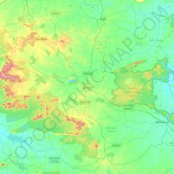
Name: Umred topographic map, elevation, terrain.
Location: Umred, Nagpur District, Maharashtra, 441203, India (20.65078 78.97020 21.04664 79.42223)
Average elevation: 922 ft
Minimum elevation: 774 ft
Maximum elevation: 1,371 ft
Make a donation
Gear up for your next adventure:
As an Amazon Associate, this site earns from qualifying purchases at no extra cost to you.
Other topographic maps
Click on a map to view its topography, its elevation and its terrain.