
Make a donation
Gear up for your next adventure:
As an Amazon Associate, this site earns from qualifying purchases at no extra cost to you.
Harperscheid topographic map
Click on the map to display elevation.
Make a donation
Gear up for your next adventure:
As an Amazon Associate, this site earns from qualifying purchases at no extra cost to you.
Harperscheid
Der 1906 geborene Einwohner Harperscheids, Karl Collas, erstellte in den 1970er Jahren eine Chronik von Harperscheid und Schöneseiffen, in welcher er die Geschichte der beiden Höhenorte skizziert. Die in der Chronik zusammengefassten Aufzeichnungen reichen zurück bis um das Jahr 1200 und zeigen die zum Teil schwierigen Verhältnisse der Bewohner der Grafschaft Schleiden, die durch stetig wechselnde Fürsten begründet waren.
Make a donation
Gear up for your next adventure:
As an Amazon Associate, this site earns from qualifying purchases at no extra cost to you.
About this map
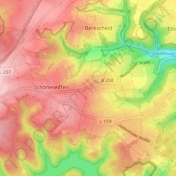
Name: Harperscheid topographic map, elevation, terrain.
Average elevation: 1,755 ft
Minimum elevation: 1,355 ft
Maximum elevation: 2,005 ft
Make a donation
Gear up for your next adventure:
As an Amazon Associate, this site earns from qualifying purchases at no extra cost to you.
Other topographic maps
Click on a map to view its topography, its elevation and its terrain.
53937
Deutschland > Nordrhein-Westfalen > Kreis Euskirchen > Schleiden > Morsbach
Average elevation: 1,647 ft