
Otting topographic map
Click on the map to display elevation.
About this map
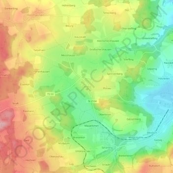
Name: Otting topographic map, elevation, terrain.
Average elevation: 1,775 ft
Minimum elevation: 1,516 ft
Maximum elevation: 2,064 ft
Other topographic maps
Click on a map to view its topography, its elevation and its terrain.
Waginger See
Deutschland > Bayern > Landkreis Traunstein > Waging am See > Fisching
Der See friert auch heute noch in strengen Wintern zu. Bis in die 1960er Jahre war das fast alljährlich der Fall. Der Waginger See friert wegen der höheren Durchschnittstemperatur und wohl auch wegen größerer Strömungen einige Tage später zu als der Tachinger See. Nur bei lang andauernden und extrem…
Average elevation: 1,522 ft